
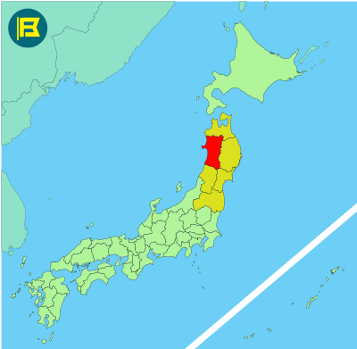
Akita is located in the northwestern part of Honshu within the Tohoku region. It covers around 11,637 km², making it the 6th largest prefecture in Japan by area.
Akita is bordered by Aomori to the north, Iwate to the east, Yamagata to the south, and the Sea of Japan to the west. The Ou Mountains run along its eastern border.
The capital is Akita City, which sits near the coast and has a population of just under 300,000. Other notable cities include Yokote, Oga, and Daisen. Akita’s total population is around 920,000, ranking it among Japan’s least populated prefectures.
The flag of Akita was officially adopted on December 5, 1959. It features a stylized version of the katakana character “ア” (a) for Akita in white, placed at the center of a dark red field.

| Capital City | Area | 2023 Population |
| Akita City | 11,637.52 km2 (4,493.27 sq mi) | 915,691 |
Japanese prefectural flag designs are used for educational purposes under fair use. Sources include public domain and freely licensed content.


